Yesterday dawned bright and sunny and we knew it was going to be a good day for a raid. Our objective for the day was to overthrow the ruling leader of Zaqistan and annex it to our own country of Jeeplandia. We left our home-base mid morning and headed west to our destiny. We would either survive and be heroes or dead and forgotten. The trip to Zaqistan was, as usual, boring. We did notice that surrounding areas near our target were absolute ghost towns. No one roamed the streets of Terrace or Watercress. Our brains took note of this as we moved ahead in our attack. Could someone or something have beaten us to the goal of taking over Zaqistan? We would soon find out.

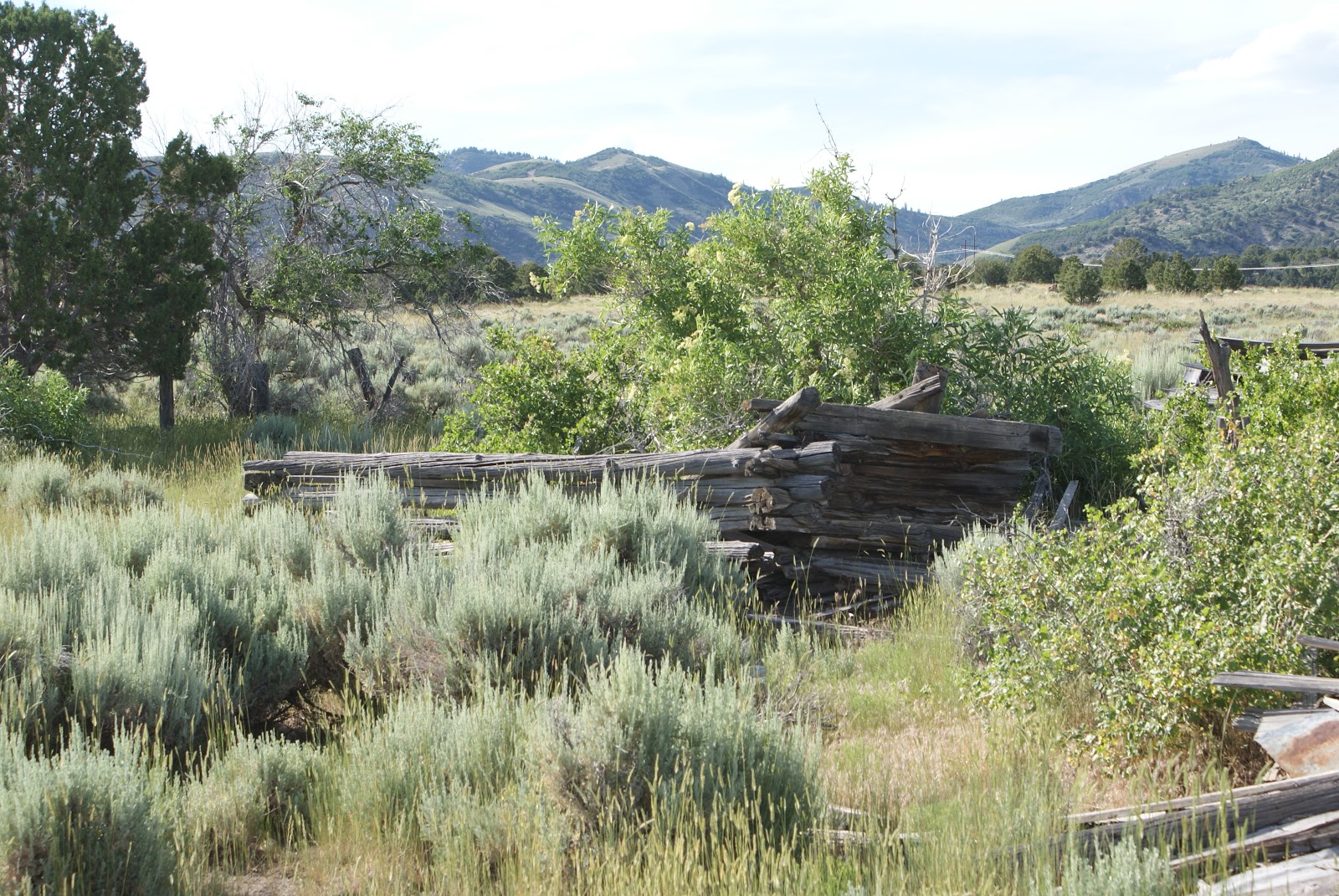
We crested the mountain that separates the free world from Zaqistan and headed down into the valley of the shadow of death. The only living objects seen were 2 Black Tailed Jackrabbits and they took off like the proverbial bats outta hell! Something wasn't right but we had our mission and we forged on ahead. Upon arrival to the border, we found nothing. Not a soul in site. Inspection of the country found all of the border guards lifeless and missing their arms. Strange, strange indeed.
Our plan of using their own jails against them went south. With no one to fight, meant no one to capture. With no one to capture, their jail cell, complete with toilet would go unused. How disappointing this all was to our battle hardened warriors. All this way in the hot desert sun for what? Nothing! So what had happened? Who beat us to this country and took it over? We might never know.

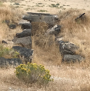
Odd things were afoot here and we needed to figure them out. One thing was certain, the place had been silent for a long time. The Zaqistans', evil as they are, are usually a clean and proper people. They would never allow their country to become dirty and downtrodden. They had prided themselves on keeping their country clean and pristine, but it was this way no longer. Even the statue of their Deity was covered in filth from birds...... or was that the sign of who's work this was? What we did know was the place was now ours. Birds or no birds we have it to ourselves! Zaqistan was now an entity of Jeeplandia. As we headed to the country's flag pole to hang our colors and claim it as ours, we realized one of us had made a mistake! Where in the hell was the our flag? It seems everyone forgot to bring a flag so we could claim the place as our own. Now who does that? Apparently, we do. DAMNIT! After a few minutes of each one of us looking at the other we decided it was time to leave and try it again at a later date. And the next time, someone will have to bring the flag.

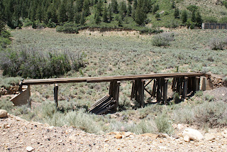
We chose a different route to go back to civilization. Instead of back-tracking to the hiway, we went cross country on the old Central Pacific Rail Bed. It has been made a road since they tore up the tracks so long ago and is quite good road at this end. As I mentioned before, the bed between Kelton and Locomotive Springs was hammered but this end was smooth sailing. They have added a bunch of markers along it now pointing out where places used to be. As I said on the web page, they have to be new cuz there ain't no bullet holes in them yet. If you want to see them, click on my website icon up above and look at the Central Pacific page.
As you can see, many of the bridges are still standing. In fact, you even drive over one of them. On this trip I did notice something new. A lot of the culverts used to allow water to go under the track were made of stone. I had read about this and placed that idea over in the Sierra Nevada Mountain area, not here in the desert. I was wrong. There were quite a few of them and like the bridges, they still work. If you ever get a chance to go out this way I suggest you do it. Spring or fall work the best because to be honest, it was too damn hot yesterday. The Jeep said the temp was 97 and I'm thinking that was low. This area is as desolate as can be. Tell someone where you are going and always carry a working spare. It seems that some spikes still exist in the road and they love to take out tires. Cell service is ok in Kelton as well as Watercress and Terrace. The 30 miles between them is blacked out so go prepared. The attack failed but the trip back was well worth it. Jeep on my friends!
Monday dawned bright and beautiful and it also meant that this trip was almost over. Since we didn't make it to Winter Quarters Saturday we had decided to try on the way home. Good plan, eh? Well the town was rather quiet on this visit and we had no trouble finding out which road to take to visit the old ghost town. Trouble was, they didn't tell us, it too was locked behind a gate. I am not mad about this tho. It seems that the coal mine that is on the other side of the mountain has reached where Winter Quarters had stopped and that they were going to move coal out both sides. So, yes, I understand. The foto shows what is left of the warehouse from the original town.

This is the sign that greeted us upon our arrival at the gate. Like I said, I understand. The town is situated in a nice canyon with a lot of trees and some sort of creek. It would be a nice place to build a cabin there and just relax. The town of Scofield is a nice place too. It isn't a very big town in fact the 2010 census has the population at 23. Since it was a holiday weekend, I would be willing to bet the population was well over 1500. The lake there is fairly good sized and there were a lot of people playing on it.
Scofield was a mining town. Coal being the mineral that the town was built around. Some reference the town as a ghost town now, but it really isn't. There are a few old buildings left standing from its beginning in 1879. It's not very big and kind of reminds me of Ophir Utah. The people we ran into were quite friendly and answered any questions I asked.
The building above is from the 1920's. There was a plaque that pointed out the various buildings left standing along with when they were built and for what purpose. I swear I took a foto of it but I'm not seeing it.
The store above was a "General Merchandise store and I can't make out the guys name on the sign that owned it. I can't believe I didn't take that foto.
I did save the best for last. This was the public school building. As old as it is, it still looks capable of holding classes this day. The grounds are fairly well maintained and you can only imagine how it would have been to go to school there. I would be willing to bet that winters there are extremely cold. The town sits at 7700 feet and that's pretty high up there. After we browsed the town we decided to go home a different way. We went over the mountain and came out in Fairview Utah. It was new territory for both of us and quite an enjoyable ride. Once we left the mountains and returned to I-15, the reality of the trip being over hit us like the 100 temperature we drove into. Still a lot of exploration to do down in that area. Who knows, I may just head back again and pick up where I left off. Jeep on my friends!
Sunday dawned nice and early and we headed out to the infamous Nine Mile Canyon. Just to get things strait, Nine Mile Canyon is a hell of a lot longer than 9 miles. So this is the first thing that you see as you begin the long journey of NMC. It also gives you advance warning that 99 % of the canyon is private property. As you pass through the canyon you begin to notice that there are a lot of old buildings scattered throughout the canyon. Some are accessible while others are not.
The first bit of Native American graffiti begins early in the drive and is properly called First site. It has a few drawings scattered about a small rock and they are easy to see and find. Like the writings in City of Rocks, these too are showing signs of wear and tear and will someday disappear.
C. W. decided way back in 1881 that he too wanted in on the graffiti so he added his name to the art area. I am sure we could find out who he was if we wanted too, but I really don't want to know. Some ass holes from modern times have also added their "artwork'' to some of the sites and that's a big no no. Modern people need to realize that this stuff left by people from the past needs to be left alone. Why it is so hard to understand this baffles me. People are really that stupid.
This old farming area had a lot of old buildings and machinery lying around. The big main building was across the street and fenced in while the other side was wide open and free to wander through. Farming is still a big thing in the canyon and most of the old time buildings are used for some purpose based on farming. This also explains why 95% of the roads lead to locked gates.
I found it interesting that there were 2 of these bull dozers in this one area. They are very old and both have been stripped down to almost nothing. They were made in either Indiana or Ohio and it would have been really neat to see these old bad boys run.
The next graffiti stop was a ways up the road. It had its own parking lot along with a Bowery and picnic tables. There is a half mile long hike you can take to see all of the writings in this area. They are pretty cool to see and i wonder what they were really saying.

Further up at almost the end of the road you come to the famous drawings. The most famous one above is known as the Great Hunt. This is regarded as one of the best drawings ever found. I will admit it is very cool, but its a long, hot way to get to it and once you have seen it, it is time to head back down the canyon to civilization. Of course we had to try every dirt road we could find that wasn't gated shut so it was fun. I forgot the map to this area so we blindly followed the GPS and saw some really pretty country. We even began filming the trail up Prickly Pear canyon and had our Samsung decide it wanted to burn. No, it did try to burn. By the way, if you smell burnt onions when you shouldn't, more than likely it is a Samsung product burning. My final thought on this canyon are mixed. Yes we saw some cool graffiti and some really beautiful canyons but I don't think I'll go back.
#1- Not a lot of Native drawings.
#2- A lot of the canyon is gated and you can't follow every road.
#3- Lack of onsite information. We came across 2 literature boxes and both were empty. Not good when you have forgotten your map
Like I said, beautiful country but the majority of it is behind locked gates and I really don't like that. If you go, plan on 6 hours and bring plenty of water and food. There is no cell service nor electricity in the area so be forewarned of that! Jeep on my friends!
So, after years of talking about it, we finally decided to go south the the Nine Mile Canyon area around Price Utah. We decided on 3 days and 2 nights with the full day dedicated to the infamous Nine Mile Canyon. Day one put us in Scofield Utah in an attempt to visit the abandoned Winter Quarters Mine. This didn't happen due to a parade, but more on that in another blog. So, we changed up the schedule and made our next in line visit the first visit. Outside of Helper Utah is a road named Canyon Road. On this road reside numerous old coal mining towns that have become ghost towns. The first of the bunch was called Peerless. This town, like the rest in the canyon enjoyed some success beginning around 1912 and dying out in the late 40's and early 50's.
Moving up the canyon you arrive and the Standardville site. Now I cannot officially say which fotos belong to which town. I can only guess and I could be wrong. The only sure thing is that these towns were close neighbors and where their dividing lines were are unknown to me. I am just documenting their remains and the fact there were towns up here to begin with. Early coal was removed by wagon until a spur line for the rail road was built into the area. I really enjoy looking at old railway bridges. They used he finest timber available and were built to last.

Everywhere you look in this canyon you can see remnants of old buildings. Due to being fat and old, I choose not to get to far off the main road on 100 degree temp days. A person could spend days up this canyon and still miss things. I would be willing to say that October would be the best time to visit this area. The temps would be cool and the leaves would be off the trees so exploration could be easier. Noon on a hundred degree day did not add any desire to venture on up some of the side canyons and see what I could find. Someday I will return with more time and better choice of weather.

At the end of Spring Canyon lie the last of the towns and mines. Though there were 3 different towns, the eventually blended into a town called Rains. There are some fotos online of this canyon during its heyday and there wasn't a lot of sagebrush to be seen. Now, it's everywhere and slowly reclaiming the entire area. As always, vandals are doing their best to destroy the old structures and keep the rest of us from seeing the past.
One common thing we noticed was burned out doors. The frame work around the doors was burned on numerous buildings that were left standing. I have to believe that this was some form of arson, yet I can't quite yet understand the why behind it. By looking inside these buildings, you can see that they were not burned down, or even on fire for that matter. It is only doorways and a few windows that have the fire marked frames and only at ground level.

During our trip up Spring Canyon we met the up to date local owner of all this wonderful area. He seemed nice enough and answered a few questions about the area we had. I really believe that he has more distrust for explorers like myself than trust. We were given our answers and he made it clear that the end of the road was gated. He was nice enough to show us where one of the mine entrances was. If you look through the doors of this building above you will notice a black hole above the cows head. This was one of the mines and he assured us that this entrance was flooded and we could not pass into it. I really hate it when assholes go to these areas and treat them with disrespect. This behavior ruins it for the rest of us who just have an odd interest in history and the past. More and more gates are being put up and cool things that are behind these gates wont be seen again. Stay tuned for more on our adventure to Carbon County Utah. Jeep on my friends!